September 2026
US Expert Weather Outlook
What our meteorologists expect this month — and what it means for your outdoor plans.
Choose your region
What to watch
What's going on with temperature
Warmer than usual across the central Plains, the South and much of the West — cooler in the Pacific Northwest
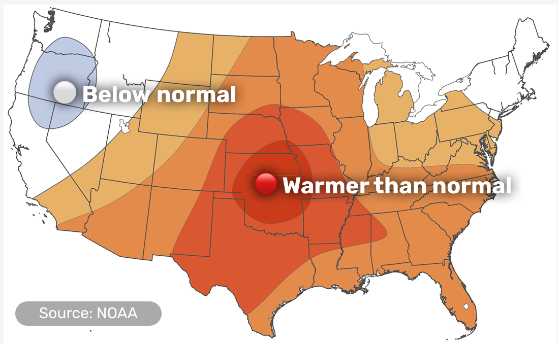
- The strongest warm signal centers on Kansas, Oklahoma, Nebraska and Missouri, where dry ground helps the heat build quickly
- The Northeast is harder to call this month, with close to even odds of ending up warmer, near normal or cooler
- Alaska leans warmer in the southeast and cooler in the west and north; Hawaii is warmer than usual too
What's going on with precipitation
Wetter than usual across the West and the Pacific Coast — drier across the central Plains
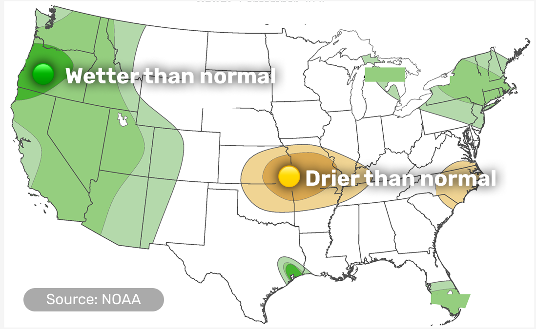
- California, the Rockies and the Southwest should see more rain than usual, with the best chances along the Oregon coast
- The central Plains and central Mississippi Valley trend drier, especially in the first ten days of the month
- Southeast Texas could get an extra soaking from Gulf moisture, which also helps South Florida
- Alaska and Hawaii both lean wetter this month
A dip in the jet stream moves through the West early in the month, while high pressure aloft builds and holds over the central Plains for much of the first ten days — that combination is driving both the heat and the dryness there.
Monsoon moisture moving north from Mexico keeps rain chances up across the Southwest and the Great Basin, while a separate dip in the jet stream brings rain to the Pacific Coast.
The Northeast sits between these patterns, which is why its temperature outlook is harder to call than the rest of the country.
ALERTA strong El Niño — still strengthening, with some chance it becomes one of the strongest on record this winter — supports the hotter, drier lean in the Plains and points to a quieter Atlantic hurricane season overall, though the season is near its historical peak, so Gulf and East Coast impacts remain possible.
Did you find this useful?
What was missing? (optional)
Thanks for your feedback.
Details by region
Scroll down or tap a region in the menu above.
Pacific Coast
WA, OR, CA

Cooler start, with rain returning
- A dip in the jet stream keeps the region cooler, cloudier and more unsettled than usual for the first part of the month
- Rain runs above normal for the whole coast, with the best chances in Oregon
- A narrow strip right along the coast stays cooler than usual too
- Wildfire potential stays above normal across most of the Northwest and far northern California, though the coast gets a break from the wetter start to the month
A passing dip in the jet stream is bringing both the rain and the cooler temperatures to the coast this month.
Interior West & Southwest
ID, NV, UT, AZ, NM, CO

Wetter, with the monsoon still running
- Rain stays above normal across the region as monsoon moisture keeps arriving from Mexico
- Temperatures lean warmer overall for the month
- Wildfire potential is still above normal in central and southern Idaho, northern Nevada and northern Utah
Monsoon moisture moving north keeps storm chances elevated here even as the broader pattern stays warm.
Northern Rockies & Plains
MT, WY, ND, SD, NE

About an average month
- Neither temperature nor rainfall shows a strong lean here this month
- Existing drought is expected to stick around, with little relief in sight
This region sits between the high-pressure dome parked over the Plains to the south and the dip in the jet stream moving through the West, so neither pattern takes over here this month.
Midwest & Great Lakes
MN, IA, MO, WI, IL, IN, MI, OH

Warmer in the south, wetter in the east
- The warm lean is strongest in the southwest of the region, closer to the heat over the Plains
- The eastern Great Lakes trend wetter than usual, which should help lake levels heading into fall
- Wildfire potential is above normal in northern Minnesota, northern Wisconsin and the western Upper Peninsula of Michigan
This part of the region sits closer to the high-pressure dome driving heat over the Plains, while the eastern Great Lakes catch more of a wetter pattern moving in from the south.
Central & Southern Plains / Lower Mississippi Valley
KS, OK, TX, AR, LA

The hottest, driest spot on the map
- This region has the strongest signal for a hotter-than-usual September, especially in the first ten days
- Rain trends below normal here too, as the same high pressure limiting clouds also limits storms
- The exception is southeast Texas, which could see a heavy soaking from tropical moisture moving in off the Gulf
- Fast-developing drought is a real risk here around Sep 10–16
- Wildfire potential is above normal across the southern Plains and the Lower Mississippi Valley too
High pressure aloft parks over this region for much of the first third of the month, and ground that's already dry lets the heat build even faster.
Southeast
MS, AL, TN, KY, GA, FL, SC, NC

Warm all month
- Warmer-than-usual temperatures are favored across the region
- South Florida picks up some extra rain from tropical moisture, though wildfire potential there is still running above normal
- Eastern North Carolina trends drier than usual, a small exception in an otherwise wetter East Coast pattern
The Southeast sits under the same high pressure driving heat over the Plains, which keeps the whole region warm; tropical moisture pushing in locally, like the extra rain reaching South Florida, is a separate factor on top of that.
Northeast & Mid-Atlantic
WV, VA, MD, DE, PA, NJ, NY, CT, RI, MA, VT, NH, ME, DC

Hard to call, but leaning wetter
- Temperature could go either way this month — warmer, near normal and cooler are all close to equally likely
- Rain trends wetter for most of the region, though a narrow strip along the coast trends slightly drier
This region sits right where a possible dip in the jet stream and higher rain odds pull the forecast in different directions, which is why temperature is harder to call here than farther south.
Alaska
AK

Mild southeast, cooler north and west
- The southeast, including the Panhandle, runs mild this month
- The west and north lean cooler than usual
- Rain trends above normal across most of the state
A dip in the jet stream forecast near western and northern Alaska is what's driving the cooler lean there; the Panhandle sits outside that influence and stays milder.
Hawaii
HI

Warm and wet, the most confident call on the map
- Above-normal temperatures are favored across all the islands, and it's one of the most confident calls in this month's outlook
- Rain also leans above normal for the month
September falls in Hawaii's dry season (May through September), when El Niño tends to bring wetter conditions — the reverse of its usual drying effect once the wet season starts in October.
This same El Niño is driving an above-normal Central Pacific hurricane season, and passing tropical systems are a major source of summer rain for the islands.
Did you find this useful?
What was missing? (optional)
Thanks for your feedback.