October 2026
US Expert Weather Outlook
What our meteorologists expect this month — and what it means for your outdoor plans.
Choose your region
What to watch
What's going on with temperature
Warmer than usual across nearly all of the West, plus the northern and central Plains and the Gulf Coast — with the strongest signals in California and Florida
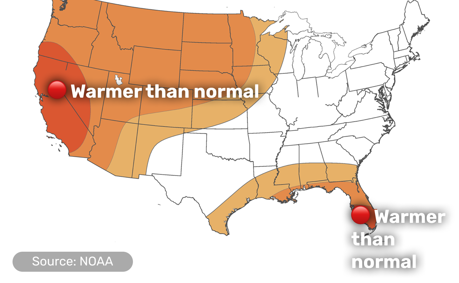
Darker color means higher confidence in that direction, not a bigger temperature swing; white areas have no strong lean either way.
- The warmest signal of the month centers on California, western Nevada and southern Oregon, with another strong pocket over most of the Florida Peninsula
- Warmth also extends across the northern and central Plains, the Upper Mississippi Valley and the area near the Gulf Coast
- A large stretch of the East — including much of the Midwest, Northeast and Mid-Atlantic — shows no strong lean either way this month
- Alaska leans warmer in the eastern Interior, southcentral and southeastern regions; Hawaii is warmer than usual across all islands
What's going on with precipitation
Wetter than usual across the southern tier, from Arizona to the Southeast — drier from the Great Basin to the Pacific Northwest
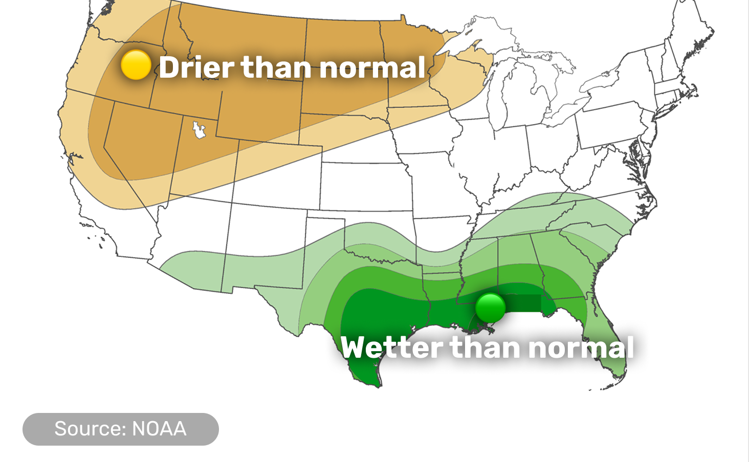
Darker color means higher confidence that the month's total rainfall lands in that category, not a bigger amount of rain; white areas have no strong lean either way.
- Rain runs above normal from southern Arizona eastward across the southern Plains, the Lower Mississippi and Tennessee Valleys and the Southeast, heaviest near the Gulf Coast and the Texas Hill Country
- Most of that rain is front-loaded into the first 7–10 days of the month, as repeated cold fronts stall near the Gulf Coast
- The Pacific Northwest, the northern and central Rockies, the northern and central Great Basin and the Upper Mississippi Valley all trend drier, with the Northwest particularly dry through at least mid-October
- Alaska's southern coast trends wetter, at least into mid-October; Hawaii leans wetter too, most for the southeastern islands
High pressure aloft dominates much of the West for most of the month, which is behind both California's warmth and the Pacific Northwest's dryness.
That same pattern is pushing a series of cold fronts toward the Gulf Coast, where they stall and pull in moisture — a southern storm track that's typical of strong El Niño winters, already emerging this early in the season.
The Southwest monsoon is fading for the year, but this year's strong El Niño and an active tropical cyclone season in the eastern Pacific raise the odds of a late-season storm — or a related surge of Gulf of California moisture — still reaching the region.
ALERTA strong El Niño — with better than 90% odds of reaching "very strong" strength this winter — sits behind the whole pattern, and intensifying drought across the southern Plains and Lower Mississippi Valley is adding its own warming boost to surface temperatures there.
Did you find this useful?
What was missing? (optional)
Thanks for your feedback.
Details by region
Scroll down or tap a region in the menu above.
Pacific Coast
WA, OR, CA

California's warm, the Northwest stays dry
- California and southern Oregon carry the strongest warm signal in the entire outlook
- Rain trends below normal across nearly the whole coast, with the Pacific Northwest staying abnormally dry through at least the first half of the month
- Later in October, a shift in the pattern could at least bring better rain odds to the westernmost edge of Washington
- Drought is expected to expand through the rest of the year in areas east of the Cascades near the Washington–Oregon border
High pressure aloft parked over the region is behind both the warmth and the dry pattern; a separate system — a Pacific trough that may shift east later in the month — is what could finally let some rain reach the Washington coast.
Interior West & Southwest
ID, NV, UT, AZ, NM, CO

Split down the middle — wet south, dry north
- Southern Arizona trends wetter this month, part of the same wet pattern reaching the Southeast, though the monsoon itself is winding down for the year; southern New Mexico is favored for above-normal rain too, mainly over the next three months
- Idaho, Nevada and Utah trend drier instead, under the same high pressure drying out the Great Basin and the Rockies; drought in Idaho is expected to expand through the rest of the year
- Warmth leans above normal across the whole region, strongest toward the California border in western Nevada
- A late-season tropical cyclone in the eastern Pacific — or a related surge of moisture up the Gulf of California — could still bring a surprise soaking to the Southwest later in the month
This region sits across the boundary between the wet pattern feeding into the Southeast and the dry high pressure parked over the northern Great Basin, which is why the split runs right through it.
Northern Rockies & Plains
MT, WY, ND, SD, NE

Warmer this month, drier in the west
- Warmth leans above normal across the region this month
- Montana trends drier, under the same high pressure affecting the northern Rockies and Great Basin, and drought here is expected to expand across the western half of the state through the rest of the year
- Northern and western Wyoming, along with most of the northern and central Dakotas, also lean toward drought persisting through year's end
- Southern South Dakota and southeastern Wyoming trend the other way, toward better rain chances and drought improvement over the next three months
The same high pressure drying out the Great Basin extends into Montana and northern Wyoming; the southern part of the region sits closer to the wetter pattern favored farther south, which is why the signal splits within the region.
Midwest & Great Lakes
MN, IA, MO, WI, IL, IN, MI, OH

Minnesota warms and dries, little signal elsewhere
- Minnesota and the Upper Mississippi Valley trend both warmer and drier than usual
- Most of the rest of the region has no strong lean on temperature or rainfall this month
- Wildfire potential is above normal in northeast Minnesota, northern Wisconsin and Michigan's western Upper Peninsula
- The exception is Missouri's Ozark region, where ongoing drought is adding its own boost to the warmth
Minnesota sits at the edge of both the warm pattern reaching north from the Plains and the dry pattern reaching east from the Dakotas, which is why it stands out from the rest of the region this month.
Central & Southern Plains / Lower Mississippi Valley
KS, OK, TX, AR, LA

Warm and wet, with Texas skies opening up
- This region sits under this month's biggest rain signal — above-normal precipitation reaching 50 to 80 percent probability near the Gulf Coast and the Texas Hill Country, most of it arriving in the first 7–10 days of October
- Warmth leans above normal near the Gulf Coast and across the Lower Mississippi Valley, where ongoing drought and dry soil are adding their own boost to the heat; inland Texas, Oklahoma and Arkansas show no strong temperature signal of their own this month
- Despite the wetter outlook, wildfire potential is still above normal in north Texas, western Oklahoma, and east Texas into the Lower Mississippi Valley — the dry stretch that's already happened hasn't been erased yet
- Widespread drought improvement is favored here over the next three months
Repeated cold fronts are stalling right along the Gulf Coast this month, pulling in moist, easterly surface flow — a southern storm track pattern that's typical during strong El Niño winters.
Southeast
MS, AL, TN, KY, GA, FL, SC, NC

Florida's hot, the rest gets rain
- Florida carries one of the strongest warm signals in the whole outlook
- Mississippi, Alabama, Tennessee and Georgia trend wetter, part of the same Gulf Coast rain pattern, concentrated in the first 7–10 days of the month
- One model disagrees on timing, suggesting a cooler-than-normal spell could arrive across the Gulf Coast and Southeast in the back half of October
- Widespread drought improvement is favored here over the next three months
The same stalling cold fronts bringing rain to the Gulf Coast reach into this region too; Florida's warmth, on the other hand, comes from the broader ridge of high pressure sitting over the southern tier of the country.
Northeast & Mid-Atlantic
WV, VA, MD, DE, PA, NJ, NY, CT, RI, MA, VT, NH, ME, DC

No strong signal either way
- Neither temperature nor rainfall shows a strong lean across most of the region this month
- Existing drought across parts of the Mid-Atlantic and southern New England is favored to improve or clear by year's end
- Maine, where drought has been slower to ease, is also favored to improve — though confidence in that call is low
Alaska
AK

Warmer east and south, wetter along the coast
- The eastern Interior, southcentral and southeastern regions lean warmer than usual; the west and north have no strong lean either way this month
- The southern coast trends wetter, at least into mid-October, as a trough sets up between the Bering Sea and the Gulf of Alaska
A trough positioned between the Bering Sea and the Gulf of Alaska is steering onshore flow into the southern coast; the west and north sit outside both the warm and wet patterns affecting the rest of the state.
Hawaii
HI

Warm and wet, before winter's drier turn
- Above-normal temperatures and rainfall are favored for all islands this month, strongest for the Big Island and Maui
- Warmer surrounding ocean waters are the main reason behind October's warmth
This wet signal is expected to be short-lived: the three-month outlook already points to below-normal rainfall taking over by November and December, as this El Niño's typical winter-drying effect on Hawaii starts to take hold.
Did you find this useful?
What was missing? (optional)
Thanks for your feedback.