August 2026
US Expert Weather Outlook
What our meteorologists expect this month — and what it means for your outdoor plans.
Choose your region:
⚠️ What to watch
What's going on with temperature
Warmer than usual across most of the West, Central/Southern Plains, and much of the South and Southeast

- The strongest warm signals are over the Southern Plains and coastal California
- The Northern Plains, Great Lakes and Northeast are harder to predict, with bigger day-to-day swings
- Alaska leans warmer in the far eastern Mainland and Southeast; Hawaii is warmer than usual too
What's going on with precipitation
Wetter across the Southwest and Great Basin — drier in the Southern Plains and Pacific Northwest coast

- Monsoon moisture moving north could bring wetter periods as far as the Rockies
- Drier conditions are favored across the Southern Plains and the Washington/Oregon coasts
- Most of the eastern U.S. has no clear signal, though parts of the Northeast lean wetter
- Alaska leans wetter in the west and north, drier in the southeast; Hawaii leans wetter too, especially Maui and the Big Island
🤔 Why this is happening
Details by region
Scroll down or tap a region in the menu above.
Pacific Coast
WA, OR, CA

☀️ Warm, with little rain relief in the Northwest
- A warmer-than-usual August is favored, with the strongest confidence along the California coast
- Coastal Washington and Oregon lean drier; California has no strong wet-or-dry signal for the month
- Drought may persist or slowly expand across the Northwest
- Wildfire potential is above normal across the Northwest, extending into northern California
🤔 Why this is happening
Interior West & Southwest
ID, NV, UT, AZ, NM, CO

☔ More monsoon moisture, but uneven rainfall
- Wetter-than-usual conditions are favored, with wetter periods possible reaching into the Rockies
- Temperatures still lean warmer overall, though clouds and storms may interrupt the heat
- Monsoon rain may gradually ease drought in Arizona, far western New Mexico and the Great Basin — but improvement will be uneven
🤔 Why this is happening
Northern Rockies & Plains
MT, WY, ND, SD, NE

🌡️ Warm spells interrupted by Canadian air
- The temperature outlook is more changeable here than farther south, especially in the Dakotas and Nebraska
- Cooler Canadian air can bring short-lived breaks between warmer stretches
- Drought may persist or expand in parts of North Dakota and western South Dakota despite occasional storms
🤔 Why this is happening
Midwest & Great Lakes
MN, IA, MO, WI, IL, IN, MI, OH

⛈️ Alternating stormy and quieter periods
- The northern Midwest and Great Lakes may swing between warm spells and cooler periods; southern parts lean warmer
- Storms are more likely earlier in the month; by mid-August, the cooler, stormier pattern shifts toward the Northeast
- Parts of Minnesota, Wisconsin and western Iowa that miss the heavier storms could see drought develop or worsen
🤔 Why this is happening
Central & Southern Plains / Lower Mississippi Valley
KS, OK, TX, AR, LA

🔥 The main heat zone
- This region has one of the country's strongest signals for a hotter-than-usual August
- Drier-than-usual conditions are favored, though occasional storms may interrupt the heat
- NOAA highlights a mid-August extreme heat risk, with the possibility of drought developing quickly
🤔 Why this is happening
Southeast
MS, AL, TN, KY, GA, FL, SC, NC

☁️ Hot, with highly variable rainfall
- Warmer-than-usual temperatures are favored
- There's no clear wet-or-dry signal for the month as a whole — it depends on which weather systems pass through
- A wetter start to August should help existing drought gradually ease
- Extreme heat may become a concern around mid-month, with tropical moisture as a wildcard
🤔 Why this is happening
Northeast & Mid-Atlantic
WV, VA, MD, DE, PA, NJ, NY, CT, RI, MA, VT, NH, ME, DC

🌧️ More changeable, with better rain chances
- Around mid-August, the jet stream may dip south, bringing cooler Canadian air and more weather systems into the region
- Parts of the Northeast lean wetter, and more frequent rain should gradually ease drought — recovery may be slower in parts of the Mid-Atlantic where groundwater remains low
- This doesn't mean constant rain or a cool month overall — just a more changeable pattern than farther south
🤔 Why this is happening
Alaska
AK

☔ Wetter in the west and north
- Low pressure may bring unsettled weather to central Alaska early in August, shifting toward western Alaska by mid-month
- Western and northern Mainland Alaska lean wetter, while Southeast Alaska leans drier
- The temperature outlook is mixed, with the clearest warm signal in the far eastern Mainland and Southeast
🤔 Why this is happening
Hawaii
HI

🌺 Warmer and wetter than usual
- Above-normal temperatures are favored across all the islands
- August also leans wetter, with above-normal rainfall favored overall
- This is about total rainfall over the month, not rain every day — no drought development is expected
🤔 Why this is happening
September 2026
US Expert Weather Outlook
What our meteorologists expect this month — and what it means for your outdoor plans.
Choose your region:
⚠️ What to watch
What's going on with temperature
Warmer than usual across the central Plains, the South, and much of the West — with a pocket of cooler air in the Pacific Northwest
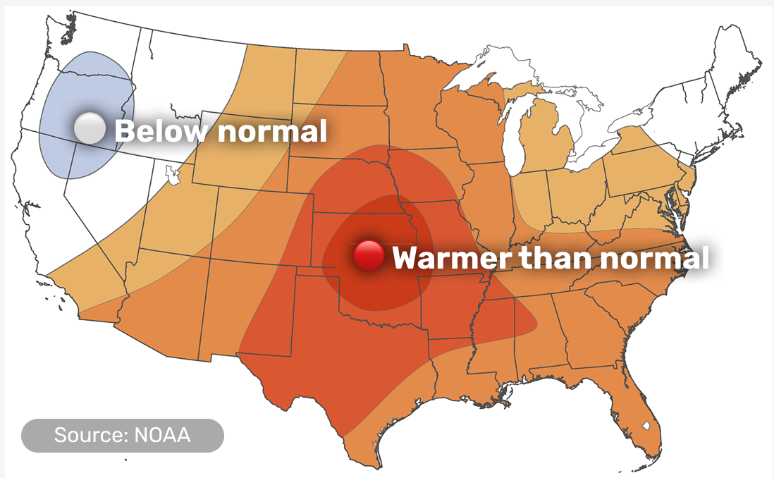
- The strongest warm signal is centered over Kansas, Oklahoma, Nebraska and Missouri, where dry ground is helping the heat build quickly
- The Northeast is harder to predict this month, with close to even odds of ending up warmer, near normal, or cooler
- Alaska leans warmer in the southeast and cooler in the west and north; Hawaii is warmer than usual too
What's going on with precipitation
Wetter than usual across the West and along the Pacific Coast — drier across the central Plains
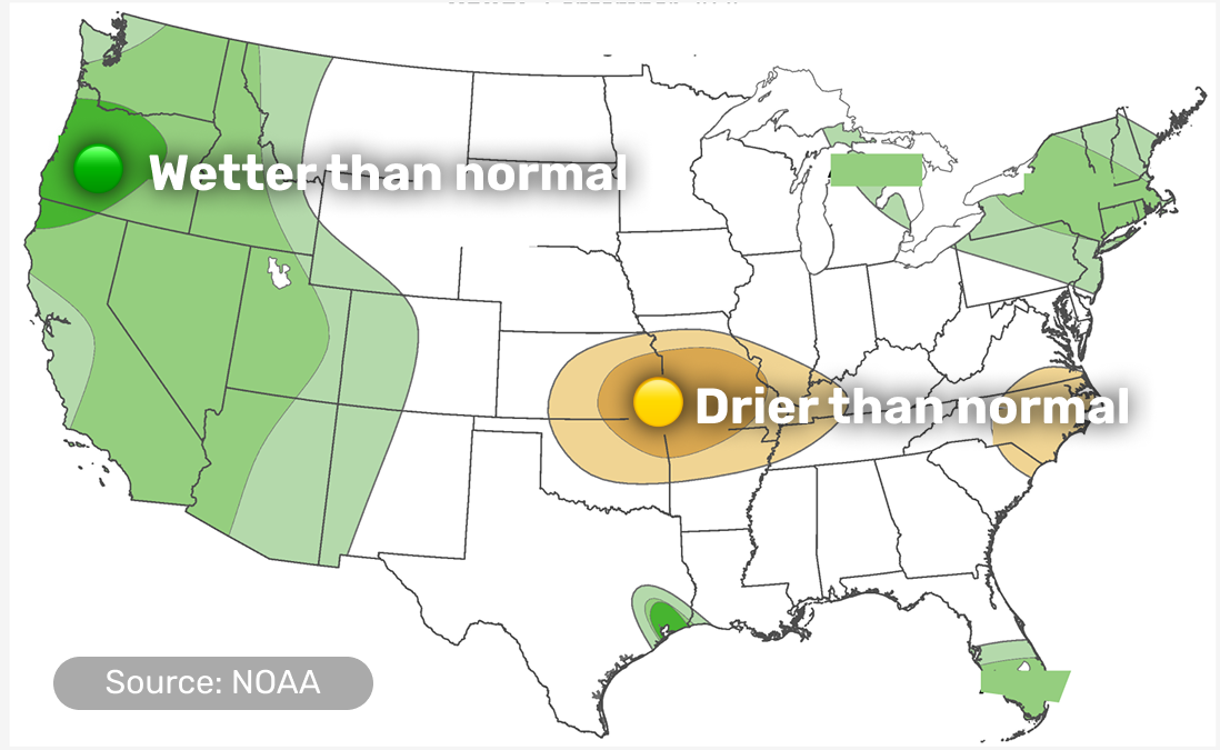
- California, the Rockies and the Southwest should see more rain than usual, with the best chances along the Oregon coast
- The central Plains and central Mississippi Valley trend drier, especially in the first ten days of the month
- Southeast Texas could get an extra soaking from tropical moisture moving in off the Gulf, and the same moisture helps South Florida
- Alaska leans wetter across most of the state; Hawaii leans wetter too
🤔 Why this is happening
Details by region
Scroll down or tap a region in the menu above.
Pacific Coast
WA, OR, CA
🌊 Cooler start, with rain returning
- A dip in the jet stream keeps the region cooler, cloudier and more unsettled than usual for the first part of the month
- Rain runs above normal for the whole coast, with the best chances in Oregon
- A narrow strip right along the coast stays cooler than usual too
- Wildfire potential stays above normal across most of the Northwest and far northern California, though the coast itself gets a break from the wetter start to the month
🤔 Why this is happening
Interior West & Southwest
ID, NV, UT, AZ, NM, CO
☔ Wetter, with the monsoon still running
- Rain stays above normal across the region as monsoon moisture keeps arriving from Mexico
- Temperatures lean warmer overall for the month
- Wildfire potential is still above normal in central and southern Idaho, northern Nevada and northern Utah
🤔 Why this is happening
Northern Rockies & Plains
MT, WY, ND, SD, NE
🌾 About an average month
- Neither temperature nor rainfall shows a strong lean here this month
- Existing drought is expected to stick around, with little relief in sight
🤔 Why this is happening
Midwest & Great Lakes
MN, IA, MO, WI, IL, IN, MI, OH
🌤️ Warmer in the south, wetter in the east
- The warm lean is strongest in the southwest of the region, closer to the heat over the Plains
- The eastern Great Lakes trend wetter than usual, which should help lake levels heading into fall
- Wildfire potential is above normal in northern Minnesota, northern Wisconsin and the western Upper Peninsula of Michigan
🤔 Why this is happening
Central & Southern Plains / Lower Mississippi Valley
KS, OK, TX, AR, LA
🔥 The hottest, driest spot on the map
- This region has the strongest signal for a hotter-than-usual September, especially in the first ten days
- Rain trends below normal here too, as the same high pressure limiting clouds also limits storms
- The exception is southeast Texas, which could see a heavy soaking from tropical moisture moving in off the Gulf
- Fast-developing drought is a real risk here around Sep 10–16
- Wildfire potential is above normal across the southern Plains and the Lower Mississippi Valley too
🤔 Why this is happening
Southeast
MS, AL, TN, KY, GA, FL, SC, NC
☀️ Warm all month
- Warmer-than-usual temperatures are favored across the region
- South Florida picks up some extra rain from tropical moisture, though wildfire potential there is still running above normal
- Eastern North Carolina trends drier than usual, a small exception in an otherwise wetter East Coast pattern
🤔 Why this is happening
Northeast & Mid-Atlantic
WV, VA, MD, DE, PA, NJ, NY, CT, RI, MA, VT, NH, ME, DC
🌦️ Hard to call, but leaning wetter
- Temperature could go either way this month — warmer, near normal, and cooler are all close to equally likely
- Rain trends wetter for most of the region, though a narrow strip along the coast trends slightly drier
🤔 Why this is happening
Alaska
AK
❄️ Mild southeast, cooler north and west
- The southeast, including the Panhandle, runs mild this month
- The west and north lean cooler than usual
- Rain trends above normal across most of the state
🤔 Why this is happening
Hawaii
HI
🌺 Warm and wet, the most confident call on the map
- Above-normal temperatures are favored across all the islands, and it's one of the most confident calls in this month's outlook
- Rain also leans above normal for the month