November 2026
US Expert Weather Outlook
What our meteorologists expect this month — and what it means for your outdoor plans.
Choose your region
What to watch
What's going on with temperature
Warmer than usual across the northern tier and both coasts, strongest from the Northern Plains to the Upper Mississippi Valley — with little lean across the southern Southwest and Texas
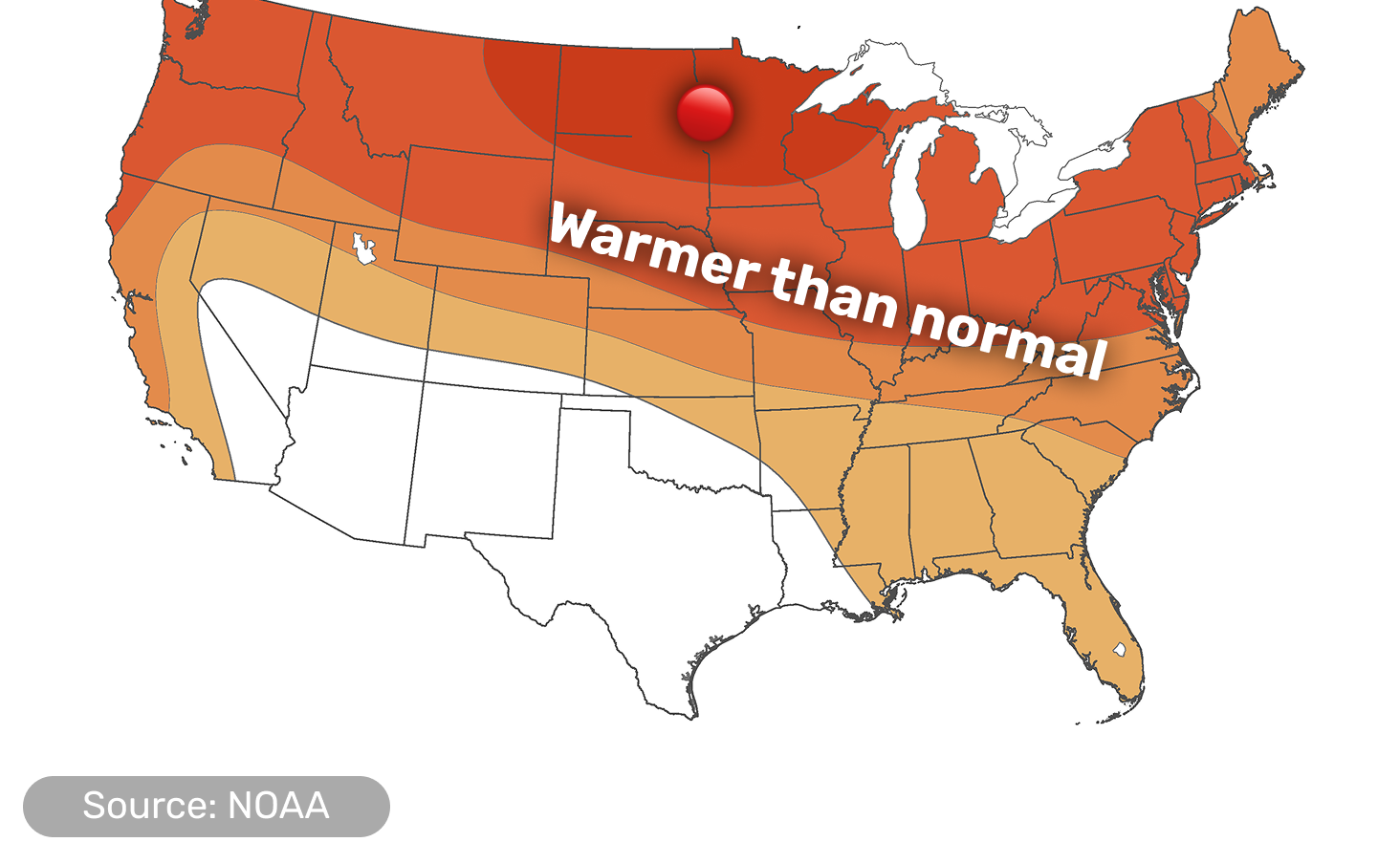
Darker color means a higher probability that the month lands in that category compared with the 1991–2020 average, not a bigger temperature swing; white areas have no strong lean either way, which is not the same as normal weather.
- The strongest warm signal covers the Dakotas, Minnesota and the Upper Mississippi Valley, and the warm lean stretches from Washington and Oregon across the northern tier to the Great Lakes, Ohio Valley and Northeast
- Much of the Southeast and Florida also leans warmer, though with less confidence, since a cooler pattern could set up there late in the month
- The southern Southwest, Texas and parts of Oklahoma and Louisiana show no strong lean either way, because forecast guidance disagrees most there
- All of Alaska leans warmer, strongest in the east and south; Hawaii is warmer than usual across all islands
What's going on with precipitation
Wetter than usual across the Southwest, California and the central and southern Rockies, plus the Texas and Gulf Coast corridor and the north-central Plains — with no strong lean across the Midwest and East
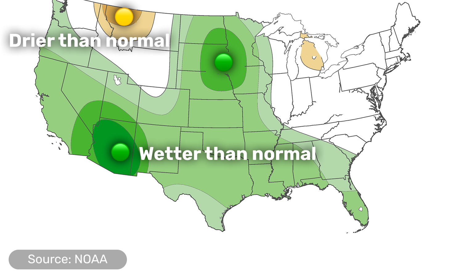
Darker color means a higher probability that the month's total precipitation (rain plus the water content of snow) lands in that category compared with the 1991–2020 average, not a bigger amount; white areas have no strong lean either way.
- The strongest wet signal is over Arizona, with southeastern California, the Great Basin and the central and southern Rockies also leaning wetter
- North Dakota, South Dakota and Minnesota also lean wetter, helped by moisture arriving early in the month over areas that had been dry
- Texas and the Gulf Coast lean wetter too; the Pacific Northwest leans slightly wetter, with the timing of the wet spells still uncertain
- Small drier pockets sit over northwestern Montana, Michigan's Lower Peninsula and southwestern Alaska; Hawaii leans drier across all islands
Early in the month, higher-than-normal pressure aloft sits over Canada and the northern US, while a weak, fast-moving dip in the jet stream crosses the southern tier. By mid-month a dip in the jet stream off the West Coast strengthens toward the coast and high pressure builds downstream, spreading south and east. By the end of November the pattern increasingly resembles a classic El Niño response, forecasters say.
Forecasters see a possible long-distance link between some of the Pacific moisture and Tropical Storm In-Fa far to the west, as the storm's energy merges into the jet stream, though its effects could land farther north than California. Earlier, the eastern Pacific produced an active run of tropical cyclones, including Hurricane Vance, whose remnants brought heavy rain to western and central Texas.
Forecasters are also watching for a rare, early-season disruption of the polar vortex high above the surface. Events like this usually favor a negative Arctic Oscillation, which can bring colder air into the eastern US, and their effects can last up to two months, but they compete with El Niño's pattern, which is why confidence is lower for the eastern US and the warm signal there is tempered. The timing and reach of any cold air remain uncertain.
ALERTEl Niño is strengthening, and NOAA's early-October update gives better than even chances that the ocean event reaches historic strength this winter. That describes the strength of the ocean warming, not extreme weather in every state. Meanwhile, drought is deepening in the Lower Mississippi Valley, where dry soil can add to daytime warming.
Did you find this useful?
What was missing? (optional)
Thanks for your feedback.
Details by region
Scroll down or tap a region in the menu above.
Pacific Coast
WA, OR, CA

A wetter pattern builds, with a stormy spell around mid-month
- Temperatures lean above normal along the coast, most clearly across Washington and Oregon
- Precipitation leans above normal for California and slightly above for the Pacific Northwest, which has been below normal on rainfall over the past 30 days; exact timing of the wet spells is still uncertain
- A moderate risk of heavy rain, high-elevation snow in the Klamath and Sierra Nevada mountains, and strong coastal winds is posted for the Pacific Northwest and northern and central California around mid-month, though the latest guidance has weakened the signal and snow levels are expected to stay high
- Drought in western Oregon and Washington is expected to ease
A persistent area of low pressure aloft over the northeastern Pacific sends successive fronts toward the coast, and a long plume of moisture is forecast to approach it. Forecasters are more confident in this active pattern than in exactly where the heaviest rain and snow will land, since some guidance steers the heaviest moisture farther north into British Columbia and Alaska.
Interior West & Southwest
ID, NV, UT, AZ, NM, CO

Another round of rain for an already soaked Southwest
- Arizona carries the strongest wet signal in the whole outlook, with the Great Basin and the central and southern Rockies also leaning wetter
- Over the past two months, southern California, southern Nevada and most of Arizona and Utah have received two to four times their normal rainfall, and the wet fall has also reached New Mexico
- Energy from the southern jet stream could bring heavy rain to the Southwest and Four Corners in mid-November, with a flooding concern where the ground is already saturated; high-elevation heavy snow is possible in the Great Basin and Rockies
- The recent rain has ended short-term drought here, though longer-term drought remains in some areas; further improvement is expected in the Southwest and eastern Utah, while the rest of the Great Basin shows little change
- Idaho leans warmer than usual; the southern Southwest shows no strong lean either way
The wet fall is tied in part to the active tropical cyclone season in the eastern Pacific driven by El Niño, which fed moisture into the region, including a storm at an unusually low latitude for the season over Halloween weekend.
Northern Rockies & Plains
MT, WY, ND, SD, NE

The country's strongest warm signal, plus early-month moisture in the Dakotas
- The Dakotas carry the strongest warm signal in the whole outlook, and the rest of the region leans warm too, though early-month precipitation may cause some cooling in the Dakotas
- North Dakota and South Dakota lean wetter, while central Montana and Wyoming show no strong lean; a small area in northwestern Montana leans drier
- The wet lean rests largely on early-month moisture; around the middle of the month a drier stretch is favored from the Northern to the Central Plains, so a wetter month can still include a long dry spell
- Widespread rain of 0.5–2 inches at the start of November eased drought in parts of the Northern and Central Plains and removed most of the extreme drought in the Nebraska Panhandle
- Drought across most of the region is expected to change little
Higher-than-normal pressure aloft over the northern tier early in the month favors warmth across this region, while early-month precipitation across the Plains is what tilts the Dakotas toward a wetter month.
Midwest & Great Lakes
MN, IA, MO, WI, IL, IN, MI, OH

Warmer than usual, with a late first freeze and drought lingering in the south
- Minnesota and the Upper Mississippi Valley carry the strongest warm signal, with a slightly weaker one across the Great Lakes and Ohio Valley
- Minnesota leans clearly wetter, while Michigan's Lower Peninsula leans slightly drier; most of the rest of the region has no strong precipitation lean
- In mid-November, near-freezing nights are possible across the Middle Mississippi Valley and Ohio Valley; where a freeze does occur, it would be the first of the season for many places, 2–3 weeks later than usual, and could affect sensitive vegetation
- Heavy early-month rain of 1.5 inches or more ended short-term drought across nearly all of Minnesota and western Wisconsin, but drought expanded across southern Missouri and deepened in Kentucky, Indiana and Illinois
Higher-than-normal pressure aloft over the northern tier is behind the warm lean. The warm signal is weaker farther east because a possible disruption of the polar vortex could bring cooler spells later in the month.
Central & Southern Plains / Lower Mississippi Valley
KS, OK, TX, AR, LA

Rain is in the forecast for a region in deepening drought
- Texas and the Gulf Coast corridor lean wetter, and drought is expected to ease across the Lower Mississippi Valley and the Southern Plains
- Drought has intensified quickly in Arkansas, Louisiana and Mississippi, with more than 4 inches of rain missing over the past 60 days and temperatures 6–10°F above normal since early September
- Remnants of Hurricane Vance brought 1–1.5 inches or more to western and central Texas, and western Oklahoma picked up near an inch or more on November 2
- A storm system crossing the southern tier is forecast to bring showers and thunderstorms to Texas and the Gulf Coast around the second week of the month, with a risk of localized flash flooding in southern Texas
- Temperatures show no clear lean in Texas, with only a slight warm tilt across Kansas and Oklahoma
That storm system interacts with moisture from the Gulf and the Atlantic, which is what brings the showers and thunderstorms to Texas and the Gulf Coast. Temperature guidance for the southern tier disagrees more than anywhere else, so no lean is shown for Texas.
Southeast
MS, AL, TN, KY, GA, FL, SC, NC

Slightly warmer, but the end of the month is harder to call
- The Gulf states and Florida lean slightly warmer, though a cooler pattern late in the month is possible, which lowers confidence
- Rain still leans above normal near the Gulf Coast, but the wet signal was dialed back along the East Coast and Southeast because early-month guidance looked dry outside the Florida Peninsula
- Heavy rain of 2–6 inches, and more than 10 inches along the Atlantic coast, drenched central and southern Florida, which eased drought there
- Drought grew in parts of Georgia and the Carolinas, and northeastern Tennessee, while southwestern Tennessee and northern Mississippi picked up 1.5–2 inches
Guidance disagrees on whether a cooler pattern settles over the Southeast late in the month; if it does, it would weaken the warm signal. Earlier, a storm system crossing the southern tier is forecast to bring showers and thunderstorms to the Gulf Coast and Southeast.
Northeast & Mid-Atlantic
WV, VA, MD, DE, PA, NJ, NY, CT, RI, MA, VT, NH, ME, DC

Warmer than usual, with drought still a concern
- Temperatures lean above normal across the region, a bit less so in Maine; precipitation shows no strong lean either way
- In mid-November, near-freezing nights are possible across parts of the Mid-Atlantic; a freeze there would be the first of the season for many places, 2–3 weeks later than usual
- Around mid-month a dip in the jet stream near the East Coast could keep temperatures closer to normal for a time, despite the warm lean for the month as a whole
- Drought grew across northwestern New Jersey, northern Pennsylvania, the Finger Lakes and New England, and extreme drought was added in Maine's North Woods
- Drought is expected to persist in Maine, southeastern Massachusetts, New Hampshire and northeastern Vermont, though confidence is low
- Lingering cold air behind early-month fronts keeps periods of scattered showers and lake-effect showers going downwind of the Great Lakes
Lingering low pressure aloft over the Northeast early in the month brings occasional disturbances and cold air that keep showers going, while high pressure settling in afterward is what opens the door to near-freezing nights.
Alaska
AK

Warm statewide, with a stormy southern coast
- Warmth leans above normal across all of Alaska, strongest in the east, southeast and southcentral regions and weaker in the west
- The southern coast leans wetter, while southwestern Alaska and the Aleutians lean slightly drier; the interior and north show no strong lean
- Around mid-month, a deep area of low pressure over the northeastern Pacific is expected to bring periods of strong winds and heavy precipitation to the southern and southeastern coast, though below the level of an official hazard
- Alaska has been drought-free since October 27
This is a typical El Niño pattern for Alaska: a deep area of low pressure over the northeastern Pacific steers storms and mild air into the Gulf of Alaska coast.
Hawaii
HI

Warm, and drier than usual as the wet season gets going
- All islands are favored to run warmer than usual, most clearly around Hilo on the Big Island
- Rainfall leans below normal on all islands as the winter wet season gets going, though the lean is modest — a drier-than-normal month on the windward side can still be a rainy one
- Hawaii remains drought-free after a very wet year; only a small area of abnormal dryness remains on the leeward Big Island
- The drier lean continues in the outlook through January
The drier lean matches both forecast guidance and the developing El Niño, and the same signal carries through the winter months.
Did you find this useful?
What was missing? (optional)
Thanks for your feedback.